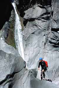
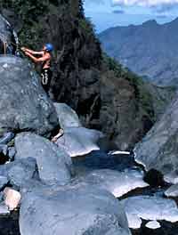
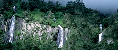
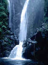
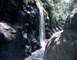
Fleurs Jaunes
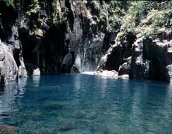
Ravine Blanche, Canyon Vert
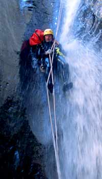
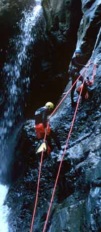
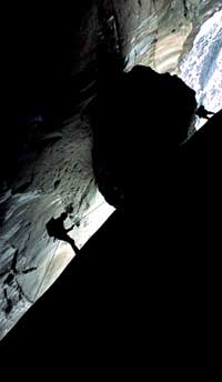
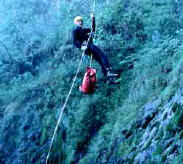
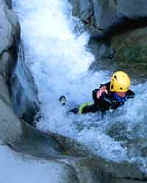
Rigging Relay, Takamaka ED+
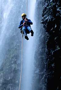
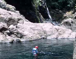
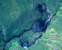
Swimmer, Fleurs Jaunes
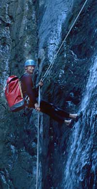
Rigging Relay, Fleurs Jaunes
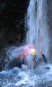
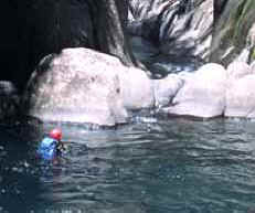
Disconnect, Fleurs Jaunes
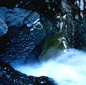
Wall Detail, Bras Rouge
One of many.......
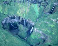
Top of Bras Rouge Sup
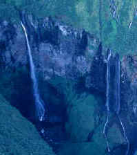
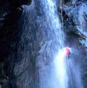
Click to see the Big Water.
John in Bras Rouge
Trou Blanc, tres aquatique.
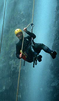
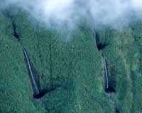
Mist, Fog, Rain. Very Wet.
Typical, Typical.
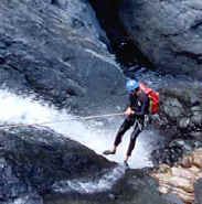
Redirect. Bras d'Etang.
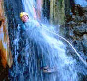
Patrick take the leap of faith.
Cyclone-placed boulder.
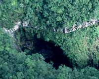
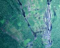
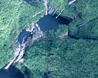
Iron Hole from ULM
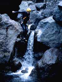
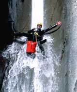
For the fun of it all.
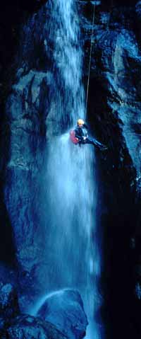
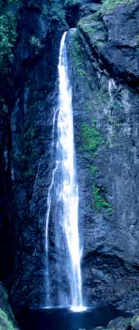
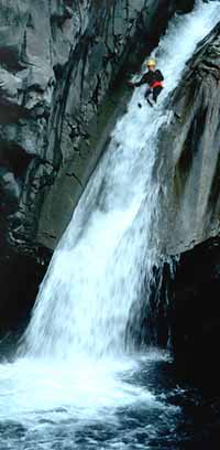
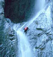
Biggest Waterslide, Trou Blanc |
INTRODUCTION
I love canyons. Mostly for their beauty - the subtlety of structure, the interplay of land and water, the glory of the
light interacting with the rock. But also for the fun of the descent, getting
actively involved with these spectacular places and using technical canyoneering
skills to access remote singularly spectacular locations. So this quest
for canyon color led me to
Reunion Island, which, from all that I could learn (off the internet, mostly),
holds one of the greatest concentration of monumental wild-water canyons on the
planet.
Reunion Island (the "place of the meeting") is located
several hundred miles east of Madagascar in the Indian Ocean. It is about 30
miles wide and 50 miles long. The highlights are towering volcanic remnants,
consisting of three major cirques, Cilaos, Mafate, and Salazie, where sunken peaks
and scarps are surrounded by steep lush walls of vines, figs, and palms. Mountains rise to almost 10,000 feet in a distance of just a few miles.
The
dramatic topography intersects the monsoonal air currents, leading to heavy
precipitation, particularly on the east-slopes, which face the persistent SE trade
winds that blow from May – October, leading to mist and cloud and
light rain even in the "dry" season. Basalt rock, porous soil, and
complex root structures in the dense vegetation capture the water and supply an
incredible array of waterfalls, ranging in height from small cascades to
towering 1500 foot drops. During the wet season (November - March) the streams
become torrents that converge into major rivers, and over the
years the resulting periodic floods have cut hundreds of dramatic canyons,
featuring steep drops and plenty of wild water year-round. Being a French territory, it was
inevitable that Canyoning (a sport pioneered in France) would eventually catch on, and in the late 1980’s
and early 90’s, many of Reunion's canyons were descended for the first time.
Reunion is now
a premiere destination for adventure sports enthusiasts. It is largely unknown
outside France, although a few other Europeans go there to climb and do canyons.
Patrick Weidman, his girlfriend Peggy, and I, were fortunate to spend a glorious
time here in June, hiking, touring, and most importantly, making technical
descents of about a dozen canyons. Some were among the most spectacular I have
ever been in. I was so impressed that I returned for a short visit in
October to do some more technical routes. The following describes these
adventures, along with some practical
information for visiting. The latter is included because it is difficult to
find in English. Indeed Americans are rare here, especially in the
highlands away from the beaches.
CANYON TYPES
There are so many canyons and so little time. What to choose?
The canyons on Reunion are loosely bunched into three generic types, labeled
Blue, Red, and Green (Canyons Bleu, Rouge, and Vert). Blue canyons are typically
found in the littoral zone on the last steep slopes leading down to the ocean. They can contain
high dryfalls, are rather open (certainly compared with the slots of the
American West), and are likely to have large boulder ("bloc") fields
in the washes that must be negotiated. Water flows down them significantly only
during the rainy season (Nov – Mar). During the dry period they will have dirty-looking
muddy puddles amongst the blocs, but few if any swimmers. Red canyons are
located further up on the coastal slope. The big ones are high up in the
mountain cirques. Crushing waterflows during the monsoonal rains have cut
awesome gorges of varying character with huge waterfalls, 200+ foot drops, narrow
throats, and permanent waterfalls cascading into huge plunge pools or lakes
("bassins"). Vegetation in-canyon is thin (a relative term).
These
canyons are more gray than green, more rock than jungle. These reminded me of an upsized Kolob (a
famous technical descent in Zion), but with water pouring through so fast that
many water-drops have to be re-directed around to get through (i.e. avoid rather than
go straight in the water). Green canyons (Canyon Vert) are uniquely different from
anything in the U.S. Primarily cut into the wet east-slope that gets over 20 feet
of rain per year, Canyons Vert feature lush valleys, green-walled gorges with
water pouring in from both sides, and huge waterwalls with multiple-level
(multi-pitch) drops. These are jungle canyons to the extreme. Canyons of the
Mist. Awesome.
We skipped the blue ones. Some have some pretty big walls (e.g.
a 250m multi-pitch vertical drop in the Grande Ravine leads down into the
ocean), and although you can
often see the coast while working your way down, most of the ones
I scouted seemed kind of ugly compared with the high-mountain and east-side
canyons. Houses can line the tops of these ravines and it’s a little hard to
get that wilderness feeling. Some are done in the heat and wet of the
monsoon season, when the high mountain canyons are impossibly dangerous. The descriptions below includes mostly Canyons Rouge, along
with two monumental Canyon Verts. The Green Canyons are so unusual (vs.
U.S. or Europe) that I liked them the best. This class also happens to
include the biggest and hairiest gigs on the Island (Ravine Blanche, Bras de
Magasin, etc).
CANYON BETA AND RATINGS
Good topographic maps can be obtained from guide shops and
tourist information centers. Six 1:25000 topos cover the island and are useful
for locating trails and forest roads. These maps are great for hiking and can be helpful
in locating canyons,
but are not terribly useful to discover access and exit routes, nor do they
provide any guidance for descents.
The book "Le Paradis du Canyoning" by Pascal Colas
(ask for it at Reunion Sensations, his tour company, in St. Gilles), is a
fantastic collection of route sketches, pictures, local lore, etc. It is, like everything
other writing found on the Island, in French. It gives brief
descriptions and rough topos for 66 canyons, including all the above
types. Ric-a-Ric (a guide shop, also in St. Gilles) sells highly detailed
topos and route descriptions that are probably more useful, even a required
item, for anyone attempting these canyons themselves. M'ric H. has been
guiding on the island 12 years or so and has a fantastic knowledge and
enthusiasm for this place. Both Colas and M'ric give time estimates that
are on the short side, i.e. to be done by pros in a hurry without photostops,
etc. Note however that canyons change, often significantly,
after each major cyclone (i.e. hurricane), the last of which was in February
2002. Before going down anything major, especially early in the dry season
after a catastrophic storm, enquire around about the state of the equipment
(bolts), blockages,
rockfalls, etc., that may be encountered. You'll need to speak French to
get very far with this. For the major expedition-grade canyons, be prepared for a
lot of playing around finding the rappel points, hacking through the jungle,
etc., during such periods. For this reason, and with a short amount of time
available for us to max
out on canyons, on our first trip we chose to go with a local canyoneer, Philippe Mothere’, who
knew the ropes (indeed!). We did more in the time we had than would have been
possible for us to do on our own.
Canyons are colorfully rated by Colas in his book as:
Peu Difficile (easy)
PD - 5 canyons
Assez Difficile
(moderate) AD - 13 canyons
Difficile (difficult)
D - 18 canyons
Tres Difficile (very
difficult) TD - 17 canyons
Extremement Difficile
(extremely difficult) ED - 8 canyons
Abominobliment
Difficile (abominable) ABO - 5 canyons
Sometimes + and –‘s are added for flavor. In terms of the
American Canyoneering Association (ACA) rating system, the correspondence is,
roughly, 3A to 3C for PD and some AD canyons (mostly of the Blue variety).
Some
AD and almost all D, TD, ED and ABO canyons are 4A or 4B (Canyon Bleu – no or
little water
flow), or 4C (Canyon Rouge or Vert, which invariably have significant water flow
that cannot be avoided). The 4 rating is because multi-pitch rappels and re-directs are usually involved
to descend the big water-walls, or to work around heavy waterfalls. ED and ABO
canyons are usually multi-day expedition-style affairs, although some ED ones
can be done in one long day (see Takamaka, below). The ABO jobs often deserve a number of X’s for wild rope moves
involving giant pendulums, throwing a grappling hook while hanging on a rope, or the like.
So how hard are these canyons, really? For those familiar
with Zion Canyons, my references and definitions of degree-of-difficulty would be
Pine Creek and Mystery (Easy), Englestead and Kolob (Moderate), Imlay and Heaps
(Hard). Colas's PD - D canyons seemed Easy to me, with TD and TD+ being
equivalent to the above-named Moderate ones. His ED canyons pair up with
Zion's "Hard" routes pretty well in. The 5 ABO canyons described in Colas's
book (Trou de Fer, Ravine Blanche, Bras Magasin, Canyon Sancho,
River of Rocks) seem a substantial step beyond, based on the one
I did, Trou de Fer.
Physically demanding, very technical, and very dangerous. Be clear on the
fact that the problems and obstacles in the Reunion Island canyons are quite
different from those that must be worked in Zion. On Reunion, even the
"easy" outings can have multi-pitch raps, and the ABO ones have
vertical drops that make your head spin. Yet there are few potholes to get
out of, and the water is not dangerously cold, etc.
THE CANYONS WE DID
GOBERT – UPPER FLEURS JAUNES
Canyons Rouge (AD). These are both easy three hour trips
with 4 or 5 non-climbable drops in each. Gobert starts out in the woods below the Isle Cordes
road that originates in the mountain village of Cilaos, and ends at a hiking trail that
you use to climb back out. The last waterfall pictured above is so slippery that
the best way to negotiate it is to slide down using a rope-assisted toboggan.
It is extremely colorful and worth
the trip to see. Upper Fleurs Jaunes (Yellow Flowers) is a short throat located
above the Isle Cordes road, while the main canyon, Fleurs Jaunes, is below
it. An
easy combo with Gobert, it has some nice-in-your face water raps and a good 20m
assisted toboggan.
FLEURS JAUNES INTEGRALE (Yellow Flowers)
Canyon Rouge (TD+). This is a Reunion Island classic.
Water goes through an
unlikely gap in the Piton Sucre, then cascades more than 110 meters down a huge
polished rock-face that is about 5 degrees off vertical. Getting through the gap
involves 4 or 5 raps, then you rap down the waterfall for a full 60m
into a clear hanging pool that spills over into another 35m drop.
Wow! After
that you can work your way down-canyon to a multi-pitch wall (two relays) that
lands in the big Bras Rouge (red arm) canyon. Waters from several canyons
combine and you follow this down into a gigantic slot (more like a huge crack
in the rock-wall) called The Vault (pictured near the bottom of this report).
Big swimmers
are followed by a 3 hour hike out on a nice trail through the jungle with
spectacular views of the area.
FERRIERE (Tool Bag)
Canyon Rouge (D+). This is a very dramatic steep-wall escapade
that quickly gets to it. You leave the Isle Cordes road just outside Cilaos and
head down. One woodsy rap leaves you out on the face of a 110m drop. A 20m
smooth slide (much like Fleurs Jaunes) deposits you out on top of a rock nose that has been
undercut by a giant alcove. 90 meters to go. Instead of using a pair of 100m
ropes, which would be put at risk on the sharp rocks of the nose, the rappel is
broken into a 30m bit, that takes you down to a relay station, somehow set up
right out on the tip of
the nose. There, hanging in space over a 60m free-drop, you re-rig and shuttle
onto the rope for a "spider wire" descent to a big pool below.
Down-canyon are several short raps, or slippery downclimbs, around very pretty
and nicely flowered cascades. Ferriere also ends up at the
Bras Rouge river. There you can investigate the big Bras Rouge Falls (or rap
it) and head downstream to The Vault, or climb up an easy trail back to the road.
BRAS ROUGE (Main Red Arm)
Canyon Rouge (TD). The lower section of Red Arm Canyon starts at
a bridge on the Isle Cordes road. Just hike a few minutes upstream (carefully on
the ledges) and rap in. A few jumps/raps/swims take you to a very interesting
drop under the bridge (rebuilt, since a cyclone swept the old one away). To
avoid the big water, a very hairy re-direct is done on the left, carefully
belaying out a slippery ledge to the relay while being rained on by heavy spray.
After that it seems easy, going down a slot with many short (up to 15m)
aside-the-water raps, jumps, downclimbs, or toboggans. Unfortunately, we
couldn’t do the whole thing as the last 50m waterfall rap was closed because 2
unfortunate souls were killed there a few weeks earlier in a rockfall,
apparently loosened up by the huge cyclone of February 2002. Update:
as of October 2002, this whole canyon is closed because of the accident.
BRAS ROUGE SUPERIEUR (Upper Red Arm)
Canyon Rouge (TD+). The upper part of Bras Rouge (Red Arm)
Canyon extends down from the cirque below Piton de Nieges (3070m) to the Isle
Cordes road. Among all the canyons on the island, its huge catchment basin, right
up in the mountains, makes it most susceptible to alterations by cyclones.
We
went prepared for anything. A difficult climb on slippery loose rock, through
some dense jungle, but near some spectacular waterfalls (the biggest being
Pissas), leads to an easy tree-rap down into the canyon. The descent starts out
wide and easy but quickly drops into a spectacular throat where the full flow of
the Bras Rouge River drops 100 feet, then jogs left and goes over a gap and drops
another 120 feet. Wild. After a hike down through some big boulders, you enter
another narrows with big drops and giant waterfalls. The biggest of the latter is avoided by
going around through a side-slot, which nonetheless rewards you with a
spectacular rap through a lesser cascade, just alongside the big fellow. Further
downstream (don’t shoot up all your film in the joys above) are further
waterside raps and swims through a convoluted narrows that features red
ferruginous streams leaching out of the walls. The exit involves a 5.7 short
climb out,
followed by a few steps to the road.
SALAZES (Sentry Canyon)
Canyon Rouge (D+). This canyon is more open than the above.
There are really no narrows or throats. The main feature is a descent down
through a beautiful cascade, featuring an in-your-face 5-step multi-pitch rap
that winds back and forth across the water, through a couple of pools, with one hanging station in the mist. Access is via the Col de Taibit trail,
and exit is as in Bras Rouge Superieur. There are about 14 raps, but the first
few are low-angle ones in the jungle. I was tempted just to downclimb these, but with
the wet slimy rock why risk ruining your trip with a sprained ankle (most common
injury here). A neat little canyon with water
pouring in from a couple of side canyons. People on the road hang out on the bridge
way below to watch you rapping down the big cascade.
BRAS D’ETANG (Arm of the Ponds)
Canyon Rouge (D+). I would rate this higher. It starts out with
easy access off the Bras Rouge Falls trail from Cilaos. A couple short raps and
400m of boulder hopping down a wide section makes it seem trivial. Then bam, the
Bras D’Etang River, which was running pretty good, drops
through a very tight sedimentary rock throat, which almost closed onto itself
into a tunnel. Dropping about 100 meters in about an equal distance,
the water
crashes down into this gorge, jogs right, then makes a final 30m drop in a
waterfall you cannot avoid. The first two drops appeared real nasty. If
you went down in the falls, you’d be forced into a notch along with all the
water. Re-direct! Unfortunately the cyclone of February 2002 had wiped out the
old relay station, so we had to rebuild it by putting a bolt into one of the larger
rounded stones imbedded in the sediment. No natural anchors here, only basketball sized
and shaped rocks held together in mud-stone. After the 30m waterfall,
you climb
around the final Bras D’Etang falls and drop into the Bras Rouge Canyon.
Downclimbing the red arm below the spectacular Fleure Jaune cascade (which we
had done a 3-pitch rap down earlier) led us again into The Vault.
TROU BLANC (White Hole)
Canyon Rouge (TD+). The Riviere de Mat near Hellbourg in the
Cirque de Salazie flows through this spectacular polished-granite canyon. The
rock is smooth, unlike the basalt blocs and fangs of the Bras Rouge, hence the
name, White Hole. This is the classic water-world canyon of Reunion. With more
water-slide
tobaggans and jumps than raps, the descent is just plain fun. There are just
two two-pitch raps (to get in) and one re-direct (with an interesting belay out to
the station). The rope work is minimal but the water is flying. Take The Jug in
Arizona, stretch it vertically by a factor or 2 or 3 and pour water in like
crazy. Narrow and convoluted, this one is dangerous w.r.t flash flooding.
But,
way cool!!
TAKAMAKA (a medicinal tree)
Canyon Vert (ED+). Oh yeah, a big one. The only canyon we got
to do in June over on the west-slope. But this is one several truly classic giant canyons
here. If you fly over this area you will see what I mean. A carpet
of jungle, where twenty foot wide palm fronds appear like dots next to the
humungous water walls. Springs gush from everywhere. Canyon after canyon, drop after drop….
Takamaka1 gets right into it. At first light we started an 80 meter 2-pitch drop
just to the left of a huge waterfall. You can see the scope of this huge canyon
spreading out below you. Vertical walls, vegetated cliffs, water falling in
everywhere. Then there’s a 4-pitch water-wall culminating in a 60m free-fall
through the mist. Finally the whole summation of water accrued thus far cascades
into a narrow gorge in what must be one of the most beautiful spots on the
planet (see picture above). Lost world, canyon of the clouds,... words pale.
Then
there’s a long (2km I suppose) narrows, with endless drops, waterfalls pouring
down the walls on both sides, colorful turns, bowls, lakes, pour-offs, palms, giant
3-meter green leaves floating by, etc. etc. Just at dusk we made it to the
hydroelectric dam that marks the end of Takamaka 1 (Takamaka 2 below the dam is
closed because of unscheduled releases).
The bummer was getting out. We had a large group and
because of the light rain we made slow progress through the canyon. The
February cyclone had obliterated what was
anyway just an overgrown path. We hacked around in the dark through the thick
rainforest, unable to avoid thorny vines, etc. Finally finding the vertical path
up the cliff face, I was glad it was dark so I couldn’t see the exposure as we
climbed up the near-vertical exit route through wet foliage and over muddy
stones and roots (which did make for gratefully solid hand holds). Some 16 hours
after we started we made it out. But, in spite of the nasty nocturnal exit, absolutely
unforgettable!! I’d do it again in a flash. Indeed in October I did
return here. The two of us did the whole thing in 11 hours, with plenty of
picture stops (12 rolls down the tubes). I swear, the lake just beyond the
3rd cascade (which is sometimes called the mini Trou de Fer) is the most
beautiful place I have ever been, and I have seen a lot in 59 years.
The Joys of Takamaka
Trou de Fer
(The Iron Hole). The 1000 foot walls of Reunion's most famous canyon.
PRACTICALITIES 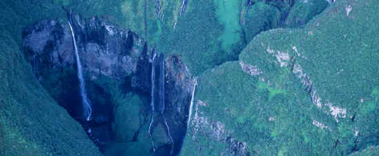
WEATHER AND THE CANYONING SEASON
The weather is what shaped the canyons over eons, and is what
changes them significantly on occasion over our lifetimes. The climate is
monsoonal. The wet season is formally "October – March".
During this
period it is hot, humid, and rainy. The "dry" season is "April
– September". But typically the rains come on slowly and sputter down
slowly, so canyons get done until mid-December, while the locals start in again
(with the big ones) in late May and early June. During this canyoning season, water
flow is
highest in May and lowest in September-October. The water is a
little warmer in October than in June. Most of the big waterfalls are permanent
year round. But the pictures you will see in the tourist shops of tons of
water cascading down the walls of Trou de Fer were taken during or just
after the rains. Nonetheless, "Dry" is something that just doesn’t
seem to happen here. Most of the Red and Green canyons have flow year-round.
The best times to visit for canyoneering appears from my limited
experience and local enquiries to be June and from mid-September
through late October. In June you can do canyons and no one else is
around!
I stayed in the VVF, a huge hostel style guest-house in Cilaos, all alone, and I only saw one other group
doing canyons the entire time. Never ran into anyone else in any
canyon. Excellent!!! According to the outfitter Ric-a-Ric, the
canyoning business is more hopping in Sept-Oct than in June. But as this is well
past the July-August French holidays, when the island is TOTALLY PACKED OUT, things
are not as crowded and there should be some bargains. I did see much more
canyon activity (i.e. a few groups) in October, and the VVF was full. One person
had told me the weather is a
little more clear in October, but that might have been a fluke. My
experience was that although October was warmer, I had just as many misty
cloudy days as in June. Clouds are
a way of life here, especially high up and on the east side. A little light rain won’t stop a canyon trip.
Several days of light rain would (or should), because of Chute de Pierre (see Hazards,
below), but such is unlikely during the time periods suggested.
CANYONING INFORMATION
Most information on the web is in French. Tour operators
are Reunion Sensations (the
agency we used - highly recommended), RicRic (best for detailed canyon topos), Austral,
and Reunion Evasion (best for gear).
A good non-commercial site on
canyoning was also most helpful.
CANYONING EQUIPMENT
The usual stuff plus:
Ample rope – dry, static, >=10.5mm. The basalt and granite
rocks have sharp edges. 8mm would be foolhardy, or at least you'd have to
be real careful. Three 60m cords would get
you through most canyons (two to play and a backup). If you’re going to try Trou de Fer,
or some of the other ABO jobs, get M'ric's guide-sheet first. You will
probably need two 100’s,
plus backup, or more. 5mm full wetsuits were adequate in June, provided you don’t
stand around. In October the water is warmer and the 5mm wetsuits were
perfect. Relay stations on the water-walls are
mostly bolted. Cyclones can obliterate bolts. We did three "quasi-first
descents" (i.e. first known down since the big cyclone of February 2002).
Many bolts had been sheared off in rock-falls, and some new stations had to be built.
Basalt is
harder than granite. Take an appropriate drill and accessories. An ascender, a shunt (for dual rope ascent), and autoblock-prussic cord are
necessary. Be prepared to do single rope descents of gargantuan magnitude
- control and an adequate brake are mandatory!
Keeping things dry is critical (esp. drill, clothes, camera,
etc.). A lightweight nylon dry-bag sealed shut inside a plastic tub that has a wide
O-ringed lid works well. Be sure to do up the dry-bag whenever it looks plausibly
wet (i.e. most of the time), and don’t cross-thread the lid of the tub. I made
that mistake, which I found out when my pack started to sink after throwing it
in before making a 5 meter jump. Almost a disaster, as I didn’t have the
dry-bag
sealed up very well either!! Spent several hours de-fogging lenses with the car’s
heater.
There is a good supply store in Cilaos: Reunion Evasion. They
have ropes, biners, etc., and even 5-10 Canyoneers! Webbing is a rarity.
The
shop had one lonely spool of webbing, but it cost more than rope. Didn’t see a
single piece of webbing in the canyons. Bolts are prevalent, but seemed less
oppressive than in sandstone slots, because these canyons are so big. Multi-pitch waterwall raps would be dangerous without bolts (IMHO).
Trees are
used for raps when possible (often this does work in Canyon Vert’s, the jungle
canyons). Boulders are used too, but are wrapped with rope. Be sure to inspect
carefully, I saw some stuff that had been through several cyclones and it looked
real raunchy.
CANYONING TECHNIQUES
The main technique that is relatively uncommon for
Utah-Arizona-Colorado canyons that I am used to is the rappel relay. Relays are
often used for multi-pitch rappels (of course), simply because the walls are too
big for one rope (or a pair of ropes). The record appears to be Ravine Blanche, where there
are ten or so relays to go down the first 1500 foot waterfall. Relays are often
also used to break up a rap so the rope does not have to run over the edge of a
sharp rock. I call these Ropesaver relays. The most dramatic is on Ferriere,
where the relay station is out on the nose of a severely undercut rock. You
hang there, with no footholds, switching over to a 60m all-free drop. Neat.
Other relays must be set up to re-direct around the big waterfalls and their
associated plunge-pool hydraulics. Some relay stations are located in the
heavy vegetation, and can be hard to get too. You
have to descend slowly, keeping an eagle eye out, then perhaps pendulum over….
The autoblock is useful in this and other relay maneuvers.
Single rope setups are used when going down through medium
water, or when using the rope-bag.
Lowering (a person) is not done. Rather the
rope is set, then someone goes down part way to make sure it is right, shunting
or ascending back up to extend or finish the rigging. Other notes on common techniques:
-
When two ropes are used, everyone raps down a tied-off double-rope (except when releasing in
deep water). Thus, all but the last person down has a
backup rope. Such double-rope raps are always used if the rope goes over an
edge, which minimizes abrasive force on each strange. It should be protected with a pack shield.
-
Check out all jumps (carry a small mask). Or climb around (which can be
just as exciting). If you can’t check the jump, or climb around, rap it. In many places the water is choppy enough that
you can’t see, and cyclones move rocks the size of houses around……Enough
said.
-
Run the return rope through a biner on your belt when pulling rope,
especially if the return rope is coming out of water where you can’t see
it. This keeps any knots from heading uphill…..
-
Trips where you hike up then go down through the canyon to the car are
much easier than those where you drive to near the top and have a long drag
back up (e.g. Takamaka!!). The big ropes are soaked, the wetsuits weigh a
ton, etc.
-
Most relay stations are equipped with small ¼ inch (or nearest equivalent
in mm) rapid links. All but the last person down should rig the rope around
an 8 that is binered to the bolt-hanger directly. Only the last person uses the
rapide. Lay out the rope carefully. Pulling fat rope through the small
rapide
is difficult. Last person down attaches a cow-tail biner through the two
ropes to minimize twisting.
LANGUAGE
French is spoken almost exclusively. It is difficult to
communicate in English. Most all maps, guides and books are in French only.
HAZARDS
Among the usual risks of canyoneering, a couple stand out here.
An extremely slippery algae grows on the permanently wet rocks (this IS the
tropics). Take it slow and stay alert. Even plain
newly-wetted rock seemed prone to slips (in spite of 5-10 Canyoneers). Chute-de-Pierre (rock falls) are the
main danger. A few weeks before we arrived two people were killed in the lower
part of Bras Rouge Canyon by falling rock (this canyon is now closed). Just after
swimming across a bassin (small lake) in Trou Blanc, ten or twenty golf-ball to
orange sized stones peppered the lake we had just crossed. You could barely see them in the air, but they came down from a couple
hundred feet up and when they hit the water it made an impression!!!! Find out
which areas are prone (many are after a rain!!), and do not sit in a bad place.
Colas's book emphasizes this danger over and over.
A major cyclone, like that in February 2002, in which a
meter of rain fell in one day, can significantly alter a canyon. We saw
bolts sheared off flush, and routes changed, with new waterfalls appearing.
Be
prepared.
Snakes, spiders and insects are not a problem. Though mosquitoes
can get bad on the coast, particularly in the summer (December), there is no malaria on the
island.
PHOTOGRAPHY
This was amongst the most difficult photography I have ever
done. 100% humidity, water everywhere, mist, fog, cold, hot, changing film under
a dripping rock, wiping the lenses off with your finger and shooting before they
fog over…. The inner gorges are dark and ASA 400 (Provia pushed 2 stops) was
required. Slide film is rare (but can be found) and slide flim processing is
virtually non-existent on the island. Print film and print processing are common.
The best 35mm lenses for canyon
photography here (as in most other places) are 28mm (most of the time) to 70mm
(for action closeups). The canyons are not as narrow as Utah's slots.
Cracks, like
The Vault, exist, but are just plain bigger!
DIVERSIONS – OTHER ACTIVITIES
Helicopter: A popular way to see the dramatic geology of the
mountainous cirques is by helicopter. Helilagon has a big operation near St.
Gilles. You’ll pay around $150 for a seat on a big 7-passenger jet ranger.
While the views are good and the ride is exciting, being in such a big heli with
windows sealed up and airconditioning adding to the noise of the rotor is a bit of a downer. Not
at all like the thrill
of riding around the aussie outback, or over the swamps of Okavango, in a cowboy
helicopter with an open bubble, leaning way out to peer over the spectacular
landscape. Besides, last year two helicopters went down, killing all involved.
Both crashes were attributed to pilot error: one was caught too near a wall and
got sucked in by
its own wash, and in the other the pilot was sun-blinded while too near the rocks. Not
recommended.
ULM (ultralight): Now this IS the real deal. For the same price
as the big commercial helicopter (i.e. $150) you can fly at slow speed (45 –
50 mph) around and over the main features for an hour and a half. Just you and a
pilot. Bouncing around in a lightweight aircraft with the huge windows wide open
(when moving at slow speed) is a gas. Fly to the Trou de Fer
(weather permitting) and over the Volcano. The red tubes and explosion craters
of the latter are very interesting from the air. In addition to the helicopter calamities mentioned above, one Cessna and one ULM went
down too. The ULM’s engine blew up, but because the landing speed is so slow,
the pilot and passenger survived. Nice to know as you are bouncing around just
above the cliffs in an aircraft held together, in part, with string. The poor Cessna
operator flew into a cloud. There are rocks in most of the clouds! Visual Flight
Rules (VFR) only! ULM's come in two flavors. A higher speed
mini-cub, and an open frame motorized hang glider sort of rig. The latter
is more exciting (or scarier as the case may be), but it will take longer to get
to the neat spots.
Examples of great canyons, from the air.
Piton de Nieges: One popular climb is to the top of the
Mountain of Snow, where in July it is possible to find an inch or two, in spite
of the sub-tropical latitude and the warm moist trade-winds. Apart from sitting atop
the highest peak in the Indian Ocean (3070m), the views of the rest of the
Island, the surrounding cirques, and especially, witnessing a sunrise from above
the tropical cloud tops, are the main reasons this is done. Most people stay over
at the Caverne Dufour cabin (2400m) and get up about 5am to make the hike to the
top. I got up at 2am and hiked all the way up from Cilaos (1200m). The hike is
not long, but is very steep (almost 6000 vertical feet). Coming down was a bitch
on the old joints, but the experience was worth it. The sunrise was a little
overrated (we get cloud-top pinks in the valley below our mountain house in
Colorado), but hiking through the interesting vegetation that inhabits the steep
cirque wall was neat. 4.5 hours up, and 5.5 down (for this 58 yo bag of bones).
Col Taibit and Trois Salazes: The Col (saddle) is a pass
between the Cilaos Cirque and the Mafate cirque. I hiked up from the Cilaos
side, a 2.5 hour trek gaining some 800 meters. I had hoped to get some shots of
the Three Sentries, famous rock towers placed like stubby fingers on the razor
edge that divides the two cirques. Unfortunately, clouds started swirling in by
the time I reached the Col. I started up the four stegosaurus-like vertical
plates you have to climb over to get to the Trois Salazes. Edgewise!
Most scary!! Maybe the mist was good ‘cause I couldn’t see the 1500 foot drops on both
sides of the two foot wide track. No rope, no visibility. Forget it.
Be great in
full sun….
Beaches: Reunion is not known for its beaches, and compared
with its neighbors Seychelles or Mauritious the beach scene is tame and mini.
Boucan Cabot (near St. Gilles) is the trendiest and a pretty nice topless
beach. When
it’s not windy L’hermitage is less crowded with tourists and has a good snorkeling
area protected by a reef wall. Saw a lot of kids enjoying this.
Piton Fournaise and the Volcano: We drove out to the crater
and hiked around a bit. The road is good, just a little mild dirt. Makes an
interesting day outing. Not active at the time we went. The hike up
(4 hours, return) is kind of neat but I thought is was more fun to see it from
the air (see Diversions, ULM).
Day Hikes: In addition to the above, the main trail system
permits access to a number of view points, overlooks, canyons, and waterfalls.
The topo maps are excellent for locating these.
Parasailing, Climbing, Diving: You name it, the "Island
of Adventure" has it. There are probably better places to dive, but some big-wall climbs, notably Piton Sucre, a sort of mini-Yosemite
next to a waterfall, and the 3 Salazes, both in the
Cilaos Cirque are popular. The parachuting was highly recommended (by a pilot…).
GETTING THERE
Reunion is a French territory that, as a state of France, does
not allow international flights. Therefore, the only flights that go there are
AirFrance and affiliates from Paris, Air Austral (a French company) from local
islands and South Africa, and Air Mauritius (which qualifies, I guess, because
Maurice is half French. Austral has a cheap connection to Mauritius, which
itself can be reached on British Air from London. But the easiest way is the
relatively inexpensive V-class flights from Paris Orly. Booked ahead, these
range from $500 to $700 (depending on time and Euro value, though not at this
price during the French holiday months of July and August). If you can get to
Paris (frequent flyers would be good….), then it’s not too hard to get to
Reunion. Warning: these flights have a "$80 penalty for a change."
However, the tiny print also says that if you do change you have to move
"one class up in service." This effectively almost doubles the price.
CARS
You need a car to reach the access points and tour the Island.
Buses are a slow alternative (speaking French advised), though small vans do
cover much of the Island during the daylight hours. Although you can rent almost
any type of vehicle, the "budget" model, typically a Renault Clio, is
adequate. These are small "mini-Cooper" style cars that are good
on gas and handy on the windy narrow streets. Since distances are short, but
tortuous, the small size (3 people plus gear) does not become too oppressive.
Most all the roads you need for access are paved, even the "forest
roads." In fact most of the forest roads that are not paved are closed off
(forestry use only). An SUV is overkill. If you rent a Clio, Twingo (or similar),
and are more than two people, do get
a 4 door. And be sure to check all the existing dings and paint scratches, and
make sure they are noted by all parties. Most rental agencies inspect
their cars with a fine tooth
comb when you bring the car back. Carry a couple color copies of your passport,
and don’t give the agency your passport or ticket. They might try to hold you up for
$400 for a little scratch. All risk insurance at $5 per day might be worth
it.
PLACES TO STAY
There does not seem to be any organized campgrounds on the
Island. In the mountains, most forest reserves and biological refuges
(conservation areas) are closed to camping. I saw a couple folks camped out on
the beach (not the popular tourist ones, but on the long deserted ones near St.
Leu). This might be OK, but it’s a long way from the great canyons of Cilaos,
Hellbourg and the West Slope. I encountered 6 backpackers on my climbs
(trail-runners
outnumbered them by 10:1), but these folks were hiking the cirque-to-cirque
(Tour des Cirques) trail, not trying to do canyons. Therefore it is best, and
most convenient, to stay in small guest houses or mountain cabins called Gites.
These typically include breakfast and dinner (half-board) for
about $35 per person per day. You should book in advance, and unless you speak
fluent French and are handy with the international telephone system, it’s best
to use an agent on the island itself to set this up. Both RicRic and ReUnion
Sensations have email and internet, while basically none of the Gites do
business this way, as yet.
FOOD
The French-Creole cooking is excellent, colorful and spicy. The
meals at the Gites were substantial in the evening, and adequate in the morning
(yogurt or fruit, bread and pastries, juice, coffee). You drink or eat your
coffee out of a bowl, which is good ‘cause you can get a lot of wake-up to
ward off jetlag. The dinners consist of a preliminary appetizer, a vegetable
entre, a main dish with rice ("rice again, quelle surprise"), rum punch,
and a dessert. Usually served family style, it’s a great way to meet the
owners, other visitors, hikers, etc., IF you speak French.
SPECIAL GEAR
Bags of desiccant to put into
the dry-bag (and maybe a small 220V hairdryer to dry them out). Thick small towels for drying off camera gear in the field.
A small water-resistant camera rig would be neat, but I was still into 3D with a
large twin-camera 35mm reflex system, multiple lenses, etc. Warm clothes. The mountain regions are a
lot colder than the coast. Saw frost a couple of times in June. Antacid
(or whatever works)
to compensate for the huge servings of great Creole cooking. Bivouac necessities – to enable
you to do multi-day descents in the big ABO or ED canyons. A synthetic bag
(La Fuma 1 kg worked great), a lightweight tarp, maybe a small pad, long
underwear, wool hat, headlamp, emergency stove, .......
THE FUTURE
Things seem to change slowly on the island. Canyoning is a
recent development. For the most part I saw no influence of man on the canyons
(other than a few bolts). However there are rumors that in a couple years much
of the high area, above the paved roads (e.g. above about 1200m) will become a
national park. Although input is still being taken, if this happens as in France
proper, where canyoning is prohibited in National Parks, many of the Reunion
Island canyons will close. Hydroelectric developments and water use by
communities are also factors that influence canyon accessibility. The former
may close Takamaka3 (ED). Might not hurt to go soon.
RECOMMENDATIONS
Here is a list of the must-do stuff (assuming you are into
canyons):
1. TAKAMAKA. Simply the most scenic spot I have ever
seen and the neatest canyon (out of 100 or more) that I have ever been in.
Wow. This is the one!!
2. FLEUR JAUNE INTEGRALE. A classic.
Beautiful.
3. TROU BLANC. Popular, but justifiably so.
Great wild-water canyon.
4. ULM flight over the east-slope canyons. See the grand
scope of nature's waterworks.
5. An Expedition Canyon. If you are up for it, it's
an unforgettable experience. Though I only did
Trou de
Fer, I doubt any of
these are as beautiful as Takamaka.
6. BRAS ROUGE SUP. If this is open, do it. The
prime example of a big-water, cyclone sensitive, rocky gorge of immense scope.
And then there are the Creole dinners, other hikes and climbs,
the La Maida overlook, etc., etc.. |